Credit for the content and layout of this site goes to "The Scorpion". I extrapolated this information from his website for two purposes: (1) to clean it up, thereby making it a little easier on the eyes, and (2) to preserve this wealth of information -- websites tend to come and go, and this material is surely worth keeping around.
There are some pretty nice mountain bike trails here, some have a lot of hills and others have obstacles. The trails can be accessed from either side of the road that runs through the park. The trails run deep into the woods, and some are not for the beginner. These trails have remained unknown to many people, even though they are fairly well maintained and there are some tough trails to contend with. To find a trail just follow the edge of the tree line and you will most definitely find an entrance, or you can enter the trails from behind the pool and swing sets. If you're tired of riding at
How to get there
From Pittsburgh Route 8 North to the Butler exit to 356 West. At the Burger King, make a right at the light, at the stop sign make a right into the gravel parking lot.
The Alleghany National Forest offers some great beginner and intermediate trail riding. The southern region near Buzzard Swamp (See separate listing) and the northern region near Salmon Creek (See separate listing) provides for real scenic riding. One of the hiking trails Beaver Meadow Loop was quite technical and fun, but nothing as hard as Frick. The scenery was great though, with wild turkey and deer. The park rangers say there aren't any particular trails dedicated to mountain bikes. They suggest the ATV trails, but this can be unsafe with ATV's traveling past at 40mph.
This is a river front trail with spectacular views of downtown Pittsburgh running north/south along the Allegheny River on an former rail line. It begins at Clemente Park, next to Three Rivers Stadium, and ends at the northern point of Washington's Landing, an Island in the Allegheny river formally known as Herr's Island. It is fairly flat, aside from an mildly elevated trek across a bridge to the island, and the trail is composed of crushed limestone on the northern 2/3's and of cement on the southern 1/3. As a city trail, you do need to share the trail with walkers, runners and other bikers, but it does not get crowded as one would expect.
How to get there
Coming into the City from any of the interstate highways, follow the signs to Three Rivers Stadium. The trail is directly on the waterfront and can be accessed at many points along the way - parking is abundant, but the best bets, to avoid paying for parking is to select on of the many lots along River Road, which runs
parallel to much of the trail or to park on Washington's Landing - where there is much less traffic.
Trail Description
This trail is part of a larger effort to convert river front property in Pittsburgh to parks and trails. It is planned to have this connect with several other fragmented trails along the rivers. It is best to avoid the southern end of the trail during any sporting events at Three Rivers Stadium, as the trail becomes clogged with fans leaving/entering/lingering and it does not make for good biking. Also, construction adjacent to the Three Rivers on two new stadiums is underway and at times has required the closing of parts of the trail.
There is a dirt road that goes from Allegheny river lock #3 for a few miles up stream (through the funny little town of Barking). It follows the railroad tracks. You can ride along the sides of the tracks both up and down stream from that road. I've found that you can ride all the way from Oakmont, past New Kensington, and in to Arnold, about 10 miles each way. It's flat and along the river the whole way, a very nice mountain bike ride.
Scenic single in-line technical trails long enough to ride all day and hit no trail twice, and there is no civilization anywhere nearby. Bavington is one of the best places to ride anywhere near Pittsburgh and you can ride their nearly all the time. There are some very technical areas and a lot of long winding trails and hills.
How to get there
a.) 22-30 west to Bavington exit (just before Starlake Amphitheater). Make a left go five miles or so and look for the sign on your right. ("State Game Lands")
or
b.) From 22 heading east take Rt. 164 east thru Portage. From PA turnpike heading east take 220 North (exit 11) to Osterburg then Rt. 869 West to Pavia. From I-80 take 220 south to Claysburgh then right to business 220 then left on Ski Gap Road. Approx. driving time from Pittsburgh is 2 hours.
Trail Description
If you park on the right of the dirt trail that you come in on, head off the road to the right and you'll go through pine forests with quick turns and a few steep hills. For a more challenging ride go back the way you came until you see an old overgrown road on your right head down the road and watch for a trail on the right. This is a very long winding and athletically challenging trail which winds around the top of some cliffs and through more pine trees finally leaving you back where you started. Both of these sets of trails along with some other trails that I don't have time to mention are some of the best places to ride in Pittsburgh and the surrounding areas. Bavington is an all day ride however and it's just not worth going for less than three hours. It's not a place you will want to leave once you get there. Ride on.
This trail is a short fun loop. It's made up of dirt roads and grassy double-track. The climb is easy and pays you off with a great downhill. The scenery is typical of the area...beautiful.
How to get there
Drive west on National Forest Road from Ridgeway. After about 5 1/2 miles you cross a wooden bridge. Just past this hang a right at the intersection and follow the signs to the parking lot at Bear Creek Recreation Facility.
Trail Description
Turn right onto Forest Road 129 out of the parking lot. Turn right onto Forest Road 339 then another right onto Forest Road 171. On this road you start to climb. After passing the top of the hill you turn left onto a rutted road. After about 200 yards you will pass a gas well. Pedal a mile or two then turn right onto Forest Road 135.1 then turn right and pedal back to the campground. A very nice trail for beginners looking to get better. Its a little over five miles long and can be longer if you take the little loops off the trail or jump onto a completely different trail. The trails are mostly made up of fire roads and roads used by the gas company. There is some grassy dual track and easy climbs.
How to get there
The Black Forest are in Susquehannock State Forest along Route 144 located in North Central PA 18 miles south of Galeton, Route 6.
Trail Description
Nice single track and fast down hills through a very rugged terrain. Keep a eye out for tree roots. There are parts where you might have to hike your bike across a beaver damn. There are some very steep climbs, fast
down hills, and old rail roads to travel. The Black Forest has every kind of riding you could be looking for, just try not to get lost. The Black Forest is known for its wildlife and rugged terrain. On this ride you might see some bear or cubs, STAY AWAY! There are also some active beaver damns along the stream. There are camp sites, cabin rentals, etc. For more information try
http://www.dcnr.state.pa.us/forestry/stateforests/forests/susquehannock/susquehannock.htm
How to get there
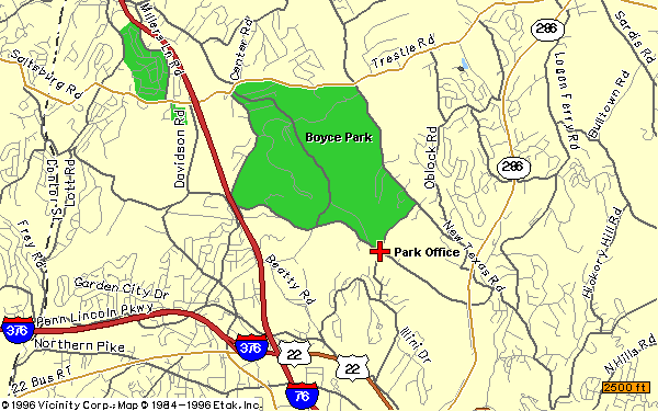
It is a little hard to give directions to Boyce Park so I made a map available.
The park is located near Monroeville. Once inside the park just look for signs
to the trails. A good place to start is at the "Log House". There are signs for
the "Log House" inside and around the park. You can find a map
here.
Trail Description
There is a trailhead leading off from the parking lot near the Soccer Field in
Boyce Park. Near the entrance of the parking lot, there is a road with a "Do
Not Enter" sign. Ride back 200 yards on this road, under some high tension
electrical lines, then look for a entrance to a wide single track on the right.
Expect cruising single track with only moderate amounts of climbing. Boyce Park has mountain biking! The trails in and around Boyce Park seem to be well cared for and
slightly altered. There is technical single track that twists through the woods and nice cruising multitrack through-out, which by the way is also used by hikers. There is a lot of traffic on the trails most of the weekend. This is a huge park. There is water and restrooms, there are also swimming pools, picnic areas, soccer fields, and more... There are no bike shops or restaurants. But food is close in nearby towns.
How to get there
Take Route 60 to Chippewa exit, turn right, go three miles to park on right.
Trail description
Trailheads lead off from near the Ice Arena. Brady's Run Park offers technical single track riding.
One of the "Month of Mud" races are held on these trails.
A short easy ride past several man-made lakes.
How to get there
From Marienville, PA drive down Route 2005 south toward the Loleta Campground. Turn left on Forest Service Road 157. Drive down this road for about two and a half miles and park in the lot.
Trail Description
Canada Goose Trail
Start out by circling the gate directly across the road from the parking lot and head down the trail. You will soon pass several man-made lakes. This trail intersects with Buzzard Swamp Trail.
Buzzard Swamp Trail
Hang a right onto the trail staying to the left. At the Y go left. At the intersection go straight through. Cross over a dam. Take a left at the next intersection. At the four-way intersection go left onto Woodsman Way Trail.
Woodsman Way Trail
Pass Songbird Sojourn Trail on the right continue left. Follow the blue diamond trail back to the parking lot.
Host of the "24 Hours of Cannan" race. NEED MORE INFORMATION PLEASE !
If you plan to make a day out of this trail in mid summer you had better pack a little extra water and some munchies. That sun gets hot and gravel trails seem to attract a little extra heat and no extra shade.
How to get there
From Pittsburgh take RT. 51 S. Towards Uniontown. The park is about 1 mile before the I-70 exit on the left.
Trail Description
The Yough River Trail runs through Cedar Creek Park, so you can jump on in either direction. From here you can head towards Pittsburgh or New Stanton. Its a flat gravel trail that runs 67 miles total. On a nice day the trail is packed with walkers and bikers. this would be another good trail to take the kids.
How to get there
Travel south on Rt.51 past Century III Mall, the entrance is on your left, right before the Eat 'N' Park and 84 Lumber. You go past a guards booth and onto a gravel road, park anywhere and follow the gravel road to the trailhead.
Trail Description
Nice singletrack that works it's way below a mountain. through streams and slag piles. Great climbing to get up the mountain and nice riding up there as well. Rocky
down hills, some technical stuff but not much.
If you don't have four wheel drive you won't make it far on the gravel road but who cares, that's what mountain bikes are for. If you do have four wheel drive you can actually drive through the cave and to the overlook. This place is a real outdoorsman's paradise.
How to get there
Go to Connellsville, coming from Pittsburgh the turn is just past Perryopolis. Cross the bridge in downtown Connellsville and make the second right onto Pittsburgh Street. Follow to the T in the road and go left. You should be on the gravel road which will lead you to the fun!
Trail Description
These are some nice trails that branch off of a gravel road which in itself is a trail (technical at times) that leads to an awesome cave and scenic overlook. The trails are mostly used by quads but are very suitable for mountain bikers. If you have a bike light try riding through the cave (it goes for miles and miles).
This trail is for the person who likes to go off the beaten path. There many technical sections that challenge even the most seasoned rider. Most the trails are singletrack through thick woods. Some parts even cross over a stream.
How to get there
Take Ohio River Blvd.. to Ben Avon. Go to Church Street and you can get on right in front of the Ben Avon
Presbyterian church.
Trail Description
There are many trails to ride and discover in the valley. There are not many logs but other things like roots and stones. I like to start at the top and go across for a long ride down the mountain. Crowding is no problem here. I rarely even see anyone else riding. It's fun and
convenient so come check it out.
This system of trails is about 20 minutes northwest of
How to get there
1:Go Northwest on I-579 to SR-28. 1.6 miles (2.6 km) 2:Go Northeast on SR-28. 18.9 miles (30.4 km) These are directions that I got from
MapQuest. When I drive there again, I will try to have this section updated with more detailed directions.
Trail Description
When you come into the park enter thru entrance #1. Drive to the parking lot at the end of this road. You will see directly ahead of you an old beat up looking road. Ride up this road, about 1/4 of a mile and you will see some dirt hills used for the park maintenance. You can either ride to the top of these and down the back of them or you can skirt them and pick up the trail behind them. As you are riding up the road you will notice a couple of off shoots onto other trails. Take them and explore them, you'll never know how much fun they are till you try them. Also, back at the parking lot if you look to the right of the old access road, all the way down by this parking lot you will see the entrance to another trail. The last time I was there it had rained the day before and these trails were extremely muddy. Occasionally, you will run across a nice little bridge to ride over and there are
a lot of creek crossings. Although these trails are not extremely difficult they do make for a fun ride and you will get a nice workout from the uphill climbs. There are also
a lot of good down hills, the only thing that I found out on these trails is that there is not
a lot of jumping and fallen trees, the trails are fairly clean except for the mud. Take a chance and try them, Hey what do ya' have to lose? At least you'll enjoy the day.
Another great place to take the family, this is a limestone track, rails to trails with several places to get on.
How to get there
Lynch Field, Greensburg, PA.
Trail Description
There are a few ruts from washouts but a very nice trail. There are benches along the way. There are porta potties and places to stop and eat. And the scenery is great. Part of the trail is paved at the Youngwood end, here it joins a small lane that cars travel. The trail is 12.5 miles long from Lynch Field to Youngwood.
Parking areas....
*Lynch Field - Have to climb a hill to the trail, past the wooden bulldozer
*East Pittsburgh Street and Highland Avenue
*Huff Avenue at the former PPG Building
*Willow Crossing Road
*Trolly Line Avenue
*Depot ST By Railroad Museum
Found within the triangle formed by the Pittsburgh neighborhoods of Squirrel Hill, Point Breeze, and Regent Square, Frick Park has what are probably the best mountain bike trails available inside the city limits. There are entrances to park trails from Beachwood Boulevard, Forbes Avenue, Braddock Avenue, Reynolds Street and Commercial (Forward) Avenue. Much of the riding in Frick park is multitrack. As it is a city park, bikers will often find themselves sharing the trails with pedestrians and their dogs.
Luckily, Frick Park does have some intermediate level technical single track, as well as some multitrack trails which see very little pedestrian use.
If you go into Frick from the entrance by the playground on Beachwood Boulevard in Squirrel Hill, and follow the trail back into the park until the pavement ends, you will find a gravel trail that leads right around a sand pile into a small open area. On the far side of that open area is the entrance to the Roller Coaster one of the most difficult technical single track trails in Frick. Early on the trail will split a number of times, as a rule take the most level path - not turning up or downhill if there is a level path. If you don't end up on a park road near Commercial Street, you haven't done the whole roller coaster. If you didn't do any climbing you might have a missed right turn immediately after the hills that give Roller Coaster it's name.
Just before the end of the paved trail, there is a rougher trail on the left. Follow that trail into the woods and out into the Ultimate Field. At the far end of the field are 2 trailheads. The left one takes you down Off Camber a tricky little descent that drops onto the main trail connecting lower Frick to the nature center trails. The right trail had two options just inside the trees. Going straight takes you down another of the most difficult trails in Frick, Out the Back, a rutted, root covered nightmare. Turning left takes you into a network of trails that lead to the Roller Coaster and Teepee Logs trail.
Entering from Beachwood at the playground again, you'll notice a carved out bowl to the left. You'll often see folks doing sled riding in the bowl during the winter. At the bottom are two entrances that lead onto the Bowl singletrack. This network of trails dumps out at a 5-way intersection of trails (landmark: fire hydrant). The Goat Path trail to the right does a steep climb to the Ultimate field, and roller coaster. The downhill multitrack will lead to the parking lot in the hollow, and the two multitrack trails which climb to the left will end up at the Frick Nature Center, and at the end of the Forbes bridge crossing the hollow near Braddock Avenue.
On the north side of Forbes 0.1 miles from the intersection with Braddock is the entrance to the public gardens. Go in this entrance, then turn right, a dirt path will work it's way back parallel to Forbes, then turn left along the edge of the hollow. Look for and take a right turn, then another as you start to descend. Garden, a tricky single little track descent into the hollow, is not recommended for the beginner rider. Depending on trail conditions, this trail can be trickier than the roller coaster.
Off of Reynolds Street in Point Breeze, past the cemetery are the lawn bowling fields. At the back of the lawn bowling fields is the entrance to the Hawthorne trail which runs along the Braddock (east) side of the hollow. For the single track rider, 50 feet past the entrance, on your right you'll find a multitrack trail going down. About 25 feet into that trail is a left turn onto a little singletrack spur we call Ridge Twisty that runs along the ridge and dumps onto the Hawthorne trail near a descent into the hollow.
There is a multitrack trail connecting the Forbes Bridge near Braddock to the Frick Nature Center. If you ride from the bridge towards the nature center you'll eventually pass a tree with 3 main trunks growing out of one spot. A singletrack descent we call Fast and Loose begins there and drops down into the hollow. Half way down there will be a left with a tree across the trail. That route ends in a very steep descent down to the bathhouse in the hollow.
If one follows the trails in the hollow to the southern end, then takes a right onto the road that the roller coaster dumps onto you'll get to Commercial Avenue. Across Commercial is a dirt lot (with a cable across the entrance). If you go into this dirt lot, then ride under the I-376 bridge and up the trail, you will have found your way to the Slag Heaps, one of Pittsburgh's less famous landmarks. You can ride trails on the Slag Heaps all the way down to the Mon.
Since there is not much riding here pack a picnic and maybe do some shopping in the outlets.
How to get there
I-79 North out of Pittsburgh and right onto exit Route 208. Then turn right into Grove City and left onto Route 58. Go straight ahead to the Grove City
Community Park.
Trail Description
A nice easy cruising trail located in a community park. There is not many trails here. Its mostly walking trails around the park. There are grades that you might decide to walk up for ease. If you do ride here and I missed something let me know.
If you take Route 28 to 910 and go north (away from the river), you will immediately go up a hill and bend to the left after getting on 910. Right near where the hill crests, there is a little poorly maintained road on your right. If you look for it, you might notice a sign for a brick company. Take this road until you come to an overpass (about 1-2 miles). Park in the turn around area just before the overpass. Ride your bike further up the road, up hill to your left. You'll ride about 200 yards and come to a power cut and trailer court. Enter the power cut to the left of the road, and when it drops off steeply in front of you, look to your right for a trail that enters the woods.
Harmarville provides miles of single track riding. The Harmarville ATB trails have recently (early summer) been logged. What condition the loggers will leave the trails in, is unclear.
Hartwood has some excellent trails with a wide variety of difficulty. Beginners can have there choice of trails as well as the more advanced. The trails are well maintained and range from single to double track. If you like jumping rocks, fallen trees, creeks and other obstacles your in for a treat here. If you get a chance and you're more advanced try out the 'Perfectly Good' trail. This trail is littered with fallen trees basically you can't go thirty feet without having to jump one. This is just one of many check it out for yourself.
How to get there
From Pittsburgh go Northwest on I-579 to State Rte 28. Go Northeast on State Rte 28 to State Rte 8. Go North on State Rte 8 (approx 8 miles). Go West on Harts Run Road (approx. 1 1/2 miles). Go North on Middle Road for approx. 1/2 mile and on the right hand side you will see a large open area with a stage this is the performing arts stage of Hartwood. You will see the parking lot at the top of the hill.
Trail Description
From the parking lot head toward the paved walking path once on the path past the
stage and heading into the woods start looking for paths on either side. I've been there numerous times and
every time I have found a new trail. There is a trail for every level of rider. If you want to take an easy
trail as you pass the stage you'll come across a small bridge about a 100 feet after that on the left there is the start of a double track trail. On either side of this trail you will see numerous single track break offs. Take any one of them for a great riding experience. There are so many trails that it is possible to take a new one each time you go riding. I'm not sure of the
distance but if you go riding here I can guarantee that you will be there all day.
There is supposedly some great single track riding at both Seven Springs and Hidden Valley. Also, there are supposed to be many miles of cruising multitrack that connects Hidden Valley and Seven Springs ski areas together. In the wintertime these trails are cross country skiing trails.
Contact the bike shop at Seven Springs or Hidden Valley for more information and maps.
The bulk of this ride is on gated roads that go pretty far out into the country. The trail is easy to follow as it is marked with orange diamonds.
How to get there
From Marienville drive north on Route 66 for about six miles. Just before the Pigeon Loft Motel hang a right onto Forest Service Road 131.1 and drive a little over 5 miles. Kelly Pines Recreation Facility will be on the left. Park and prepare yourself.
Trail Description
For Kelly Pines Trail
Campground
Pedal out of the campground and take a left onto Forest Service Road 131. Then turn left onto Forest Service Road 130.2. Next hang a left onto Forest Service Road 404. You pass a road on your left then pass Forest Service Road 404B farther down.
Trail Descent
You circle the gate on the left and begin the long descent back to camp. During the downhill ride you'll notice the remains of machinery once used to pump oil from wells. The forest used to be full of these pumping stations. Pass the road on your left. Ride through another boulder field then the camp is a short way after.
For Duhring Trail
Forest Service Road 131.1
Pedal out of the Kelly Pines camping area and turn right onto 131.1. You will notice orange diamond trail markers with black arrows inside. Follow these for the majority of the ride. After about half a mile turn right off the dirt road onto a double-track trail. At about a mile and a half you will reach a gate which you circle. The double-track hits a dirt and gravel road onto which you turn right following the orange trail markers. You will pass Forest Road 403.
Forest Road 227
When you reach the next road Forest Road 227 turn right and pedal for a while. After a while the road begins to follow Spring Creek. At about nine miles you pass a gate. Shortly after you see a huge boulder surrounded by water from a beaver dam. This is a very large rock ya can't miss it.
Descent of Death
Turn left onto the gas road a couple miles past the boulder. The road disappears and single-track begins. At this point you should fasten your seat belts and return your seat and trays to the up-right position. (You will most likely also wish for
a parachute....) Head to the left and keep your eyes open for rocks and ruts. You will be afraid. After the downhill turn left and follow the road over the bridge. Next turn left back onto the double-track and return the way you came.
The mountain bikers at the Ambridge Cycle Shop recommend the trails at Knob Hill Park. Call them for more information. This is a short ride along a golf course.
How to get there
Pick one: Take I-79 North to Warrendale exit. Turn left, then first right, and
next left to Knob Road. Knob Hill Park is the next left.
Pick two: From Pittsburgh, PA take I-79 north and exit at Warrendale then take a left. After going about 100 yards turn right and follow this road for around three quarters of a mile and take a left. You'll pass a couple baseball fields on the left then turn left into the main
entrance of Knob Hill Park. Stay to the left and go all the way to the back.
Trail Description
Knob Hill Trail
Ride out of the parking lot past a tan block building. In sixty yards turn left around a brown gate and pedal up a short hill. Turn right at the Y and then turn left at the next Y towards some smaller trees. Ride past the Frisbee Golf Station #2 and keep straight. Stay to the left. You'll pass Course Description Map #4 and head into a clearing. Take a right and pass Map #6. Head up the dirt double-track and take a left at the Y. Turn left onto the dirt road ride a little ways and turn left onto the single-track.
Crabapple Thicket
Take a left onto the single-track that winds through the crab-apple thicket. Turn left onto the double-track and then left onto an old dirt road. Hang a left onto the single-track that runs through the old field. Take the plunge into the swamp go about eighty yards and then turn left onto the single-track running through the half-grown field. You come out above several ball fields.
The Cinder Road
Hang a left and ride up a cinder road past Map #8. Take a right at Frisbee Catch Station #8 and follow the tree line turning right as you follow the trees. Roll down the hill and pass Course Description Map #9. Before you get to the catch station turn left. Pass Course Description Map #10 and enjoy the ride down onto the single-track. Turn right onto the gravel path and then another right down to your vehicle.
One of the "Month of Mud" races are held on these trails.
Laurel Highlands allows mountain biking on many of their cross country skiing and snowmobile trails. As mountain bike trails they offer everything from casual cruising on dirt roads to extremely challenging single track on the caliber of that found in West Virginia. The terrain is very rocky in places and sometimes hidden by ground cover (like a field of 3 foot high ferns) - Laurel Highlands is really beautiful.
To get to Laurel Highlands take I76 (the PA turnpike) to the Donegal exit, turn left at the exit, and about a half mile down the road turn onto PA 711 North. Take 711 a number of miles (10ish) until it hits US route 30. Head east along 30 and look for signs to Laurel Highlands and Forbes State Forest. There are multiple parking areas so you can choose to be close to the particular trails you want to ride.
The Shadyside Ski Shop runs a mountain bike rental shop at Laurel Highlands. You can stop by their rental shop or their Pittsburgh store (off Aiken in Shadyside) for maps. Their rental shop at Laurel Highlands is not a fully equipped bike shop, but they do sell Powerbars and Gatorade. Important Note: plan on either buying drinks from the shop, or bring your own water - water refills are few and far between at Laurel Highlands.
The maps that the rental shop have highlight ATB routes, but there are a lot of trails open to bikers are not shown on the map. Carry one anyway, it's easy to imagine getting lost in Laurel Highlands.
The maps distinguish between "roads" and "trails" and while roads are generally multitrack, but this doesn't ensure they provide easy riding. Beam Run Road, for example, is pretty rocky so you can't just cruise on it.
The singletrack trails at Laurel Highlands are often marked only by blaze marks. As a rule, these are pretty easy to find, but there are places where you might need to stop and look around a bit. Trails with blue and red blaze marks are open to mountain bikers. The Laurel Highlands Hiking Trail (LHHT) is marked with yellow blaze marks and is closed to ATV's, horses and mountain bikes. Be forewarned, it's quite easy to accidentally stumble onto LHHT from the other trails.
My impression was that the "best" terrain wasn't reserved for the hikers. Lots of very challenging trails are open to bikers. One patch of the LHHT we accidentally stumbled onto had some sections that were just impassable on mountain bikes. By impassible I mean, 4 foot high rocks with not enough clearance for bars or crank (maybe when my bunny hop improves).
There are to many trails here to list them all, there are enough for the beginner as well as for the hardcore. Not to mention the beautiful scenery that surrounds you everywhere you go.
How to get there
Located on Rt. 30 two miles east of Ligonier just past the Laurel Summit elevation sign. Turn right at the Laurel Mountain State Park sign. Follow the road for about two miles until you see a parking lot to your left and a blocked-off road to your right. Park in the parking lot.
Trail Description
The Downhill
The downhill is very challenging. You reach speeds of 40 mph while dodging logs,
deer and holes. Watch out for the wet high grass -- it gets slippery. The climb starts out not too steep
but the further you go the steeper it gets. The climb gets so steep it would give Ned and Tinker respiratory fits. Again the grass might give you problems if it is wet and watch for the hidden logs.
Laurel Mountain Ski Area
You can ride the killer downhill that leads to a two mile climb on the slopes of the abandoned Laurel Mountain ski area. The ski area is a mile down the blocked-off road across from where you park. Once you get to the ski
area go around the old lodge and follow the slope that is behind it to the bottom. At the bottom go straight across passing the old warming hut. Have fun climbing to the top!
The Ski Trails
There are also many X-C ski trails that loop around. You will find their trailheads right along the road. The
X-C ski trails are fast with rocky mud and quite a few logs.
Beams Run Road
For Intermediate riders there's some doubletrack like Beams Run Road. It's about 8 miles each way. Watch out for the grade 4 rocks on the downhill section if you enter the trail from the back of the parking lot.
Take Route 51 through Library, past Trax Family Farms, right turn into Mineral Beach, a swimming pool and park area. There you will find a single track 4 mile loop. (Additional trails?)
One of the "Month of Mud" races are held on this trail.
According to the locals one of the best places to ride in the area. Moraine offers tough technical riding. Lots of twisting turning single track to make you want to go faster and sharp rocks to remind you to slow down. You might want to get a map at the park since not all trails are open to mountain bikes. There are also a lot of dual track for cruising runs to enjoy the day. Steep climbs and fast rocky down hills. If you decide to bike here you might want to strap everything down a little tighter. Moraine State Park offers some of the toughest technical riding northeast of Pittsburgh.
How to get there
a.) From Pittsburgh, PA take I-79 north. Get off at Exit 29 onto Route 422 east. Drive down 422 east until you reach the first exit for Moraine State Park which is the south shore exit. Get off at this exit turn around then get back onto 422 west. The trail can only be reached from 422 west. Drive two miles down 422 west and get off at the North Shore Exit which is the first one. Follow the signs to the Moraine State Park boat marina. Before you get to the marina you'll reach an intersection of Mt. Union Road and North Shore Drive. Turn left and drive a half mile to a parking lot on the right. Maps are available at the State Park office.
or
b.) From Pittsburgh take I-79 N. Turn onto Route 422 east at exit 29. take the first exit for Moraine State Park. Head for the boat marina but turn left at the Union Road and North Shore Drive intersection. There will be a parking lot on the right. You can also follow the signs to the Mountain Bike trail.
Trail Description
Moraine Trail
You start out at a power line with some pretty gnarly rocks. After almost a mile hang a right and enjoy the curvy single-track which is also pretty rocky. You cross over Glacier Ridge Trail part of the amazing North Country Trail which is unfortunately closed to mountain biking. When you reach the Y stay to the left and climb the hill. You cross the red road and pass some old foundations on the right. Follow the shoreline when you reach it.
The Old Road
Take a right onto the old road. After a short way make a hard right off the road and start a steep climb. Turn right onto the road and head uphill again. Make a left before the gate and climb a short steep embankment then hang a hard left down the hill. Turn left at the intersection. Stay on the
power line and backtrack to the trailhead.
Fella
A seven-mile loop consisting of rock and root-infested down hills, steep climbs and beautiful views of Lake Arthur. Nearly 100 percent singletrack. Trail follows a mud- and rock-covered
power line for 1.8 miles, then enters the woods. "Woods" section combines winding climbs and descents with some easier peddling along a ridge overlooking the lake. Crosses a nice lakeside meadow and beaver bog. Offers great scenery away from crowds, and the trail is well marked. Some good technical stuff. Give yourself a few hours of riding time -- its a long seven miles that's physically exhausting. Not a problem if you're in pretty decent shape. Travel north on 1-79 from Pittsburgh, take Rt. 422 exit, New Castle. Follow signs for Moraine State Park, North Shore. Follow North Shore Drive for several miles around the lake, past the Davis Hollow Marina. After you pass the marina, look for signs for the Mtn. Bike Trail. Signs will direct you to a left turn onto a dirt road and the trailhead is at the top of the hill at the base of the
power line. Good luck!
One of the "Month of Mud" races are held on these trails.
There's nothin' out here but woods - no bike shops or water - so make sure you bring everything you need. Watch out for hunters and dirt bikes!
How to get there
From Pittsburgh take Route 30 to North Huntingdon. Make a sharp right on to Robbins Station
Road (across from Hamilton Buick). Keep following this road until you reach the very end of it. The road runs right into the park.
Trail Description
Lots of wide singletrack trails to explore. Not the most technical stuff but a lot of fun - especially the
down hills. Great for beginners but still fun for the more advanced riders.
DESCRIPTION: The trail is about 12+ miles os single track and jeep trails. Its got a little of everything, some tech. some downhill, some uphill, and some cruising. Its a well maintained trail used for horse and cross country skiing. The park station has a map of posted trails. Watch for horses and mud with flies buzzing around it. (hint hint) It has also been brought to my attention that there is a very nice single track run. It was created and maintained by the locals. It is some very nice technical single track. Several trees have been placed as obstacles. If you can't bunnyhop then you might want to stay clear of this trail. There are some very steep uphills and fast downhills.
LOCATION: Take I-79 to SR-910 East, look for the signs to North Park on your right. Park by the skating rink and bike up the road by the parking lot. Drop into the trail on your left hand side.
MISC. INFO: These trails are used
by horses so keep your eye out. If you never spooked a horse take my word for
it.... you don't want to. Also watch out for the "little droppings" that horses
leave. That might not be mud your covered in at the end of the ride.
Multitrack from Ohiopyle to Confluence along the a converted rail right-of-way, some single-track that I haven't explored much. Bike rentals are available at Ohiopyle for hourly and day rates.
Four and a half hours away from Pittsburgh by car, Pocahontas County, West Virginia is home of Snowshoe Mountain Resort and Elk River Touring Center.
Snowshoe offers 100 miles of mountain biking trails. They rate their trails by difficulty: Easiest, More Difficult, Most Difficult (just as ski slopes are rated). Their difficult trails are more difficult than anything you will find in this area (including the most difficult sections of the Laurel Highlands trails). For more information call Snowshoe's Mountain Biking center at (304) 572-1000.
The Elk River Touring Center is about 10 miles from Snowshoe and has a mountain bike shop, a bed and breakfast, and serves as trailhead for a huge network of trails. Each spring the Elk River Touring Center hosts the WVA Fat Tire Festival (described as the "Woodstock of Mountain Biking"), with races, tours, camping and evening campfire jam sessions. For more information call the Elk River Touring Center at (304) 572-3771.
How to get there
From Pittsburgh take 22 east to 286 which some turns in to 380. Follow 380 to 66 north to Apollo. After crossing the bridge turn right at the light after about a mile turn right (you will see the sign at the end of the road) onto Canal Rd the road ends at the only trailhead.
Trail Description
Roaring Run trail follows the Kiskiminetas River for about 3.5 miles, the first 1.5 miles finished. At the end of the finished part of the trail is the
bridge over Roaring Run at this point you can enter the woods onto some ATV trails and old logging roads which is mostly intermediate riding. For the expert there is some technical single track with tough climbs and challenging downhill. The trails are not marked very well and there isn't any trail maps that I know of but mostly all the trails begin and end at the Roaring Run trail.
Behind the Hills store at Robinson Towne Centre is one of two trailheads for a network of trails. These trails are also known as the Brothers Grimm trails because many riders actually enter the area from Montour Run Road across the street from this local bar/restaurant called the Brothers Grimm.
The Brother's Grimm entrance can be found by taking the Montour Run exit off the Parkway near old airport and IKEA., and turning left at the first crossroad, go past Wikes Furniture, past YMCA, around bend and right into the parking lot for a blue factory. The trailheads are near the entrance to the parking lot.
Having not ridden these trails much, I can't really comment, but the people at Ambridge Cycle Shop swear it is the best local riding.
One of the "Month of Mud" races are held on these trails.
How to get there
From the Pittsburgh area follow interstate 80 east to exit 18. Follow Rt. 153 towards Clearfield to Rt. 322 west. Follow 322 west for about 5 miles. There will a wide dirt road with a large parking area there. There will be a mailbox at the site with trail maps in it. If you travel on 322 until you come to Mitch's Restaurant, you have went about 1 mile or so too far. Turn around!
Trail Description
The series consists of 7 or 8 trails ranging from old fire and forestry roads to very, very challenging single track. The trails range in length from 2.6 miles to about 12.4 miles, all have post markers and are visibly marked with blue marks on the trees.
How to get there
Enter the forest at the Tussey Mountain Ski Area three miles from the Penn State Campus. If your going to ride there stop at the bicycle shop downtown for a trail map, it has all the best single track in the area. This trail is kept up by the locals so pay some respect while you ride here.
Trail Description
Located within Rothrock State Forest a diverse blend of fast smooth singletrack with plenty of things to stop you faster. Rocks, logs, and chutes. If you want to know what a double black diamond rating is like try this trail out and don't forget to bring the cell phone for fast medical attention. Maybe its not that bad but it is not for beginners. This trail drops 1000 vertical feet in two miles. Then there is a 4 mile dirt road climb to the trailhead.
Great views and a hard work-out are what describe this ride the best. There isn't much in the way of technical challenge but the aerobic difficulty more than makes up for this. The ride is mostly dirt and gravel roads with some grass-covered double-track thrown in to keep things interesting.
How to get there
Take Forest Service Road 128 north from Marienville for about 5 miles. Turn right into Beaver Meadows Recreation Area. Park in the parking lot.
Trail Description
Forest Service Roads
Pedal out of the parking lot hanging a right onto Forest Service Road 128. Next turn left onto Forest Service Road 127. Go straight back to a little clearing and you will see a trail marker for the ramble.
Route 1
Hang a right onto snowmobile Route 1 following the orange diamonds. At around 9 miles the trail will cross the North Country Trail. This trail is one of the longest in the world and it is open to mountain bikes. However the terrain is very rough. It is for all intents purposes unrideable. Pass it and continue on the previous trail. Shortly after this hang a right onto the hard-packed dirt road.
Forest Service Road 127
Turn right onto Forest Service Road 127 and follow the orange diamonds marked with a 7. A big climb is coming up. Continue straight on 127 passing Forest Service Road 287 on your right. Turn right onto Job Corps Road (Forest Service Road 128). Turn left back into Beaver Meadow Recreation Area and rest.
**WARNING** these are game lands and there are a lot of hunters who will shoot at anything that moves. So watch out for those guys with big guns who have been up all night drinking. On second thought, stay out of here all of buck season.
How to get there
You turn off 322 onto Scotia Rd. just North of State College. Travel this road straight till you turn onto Scotia Range Road. Once you turn onto Scotia Range Road just look for a place to stop and get the bikes out.
Trail Description
Scotia Range is located in State College. These trails are mostly dual track made up of old fire roads. This location has a ton of trails you can go on. Try to be
careful not to get lost. This area also happens to be game lands so in hunting season wear something bright and keep your head down.
Settlers Cabin county park provides access to some of the best technical single track, and multitrack riding in the Allegheny County region. Some land accessible from the Settlers trail-heads is posted against trespassing, and many of the trails that provide the best riding are difficult to find without a guide. Settlers Cabin provides access to at least 30-40 miles of networked trails. The first part though flat is filled with big holes. If it's dry get some air. If it's wet be careful some of them are deeper than they look. Also there are a couple of stream crossings and open fields where downhill speeds reach about 35 mph. To balance the good features of Settlers you'll also find lots of poison ivy, crab apple thorns and numerous recorded encounters with deer ticks.
How to get there
Option One: From the city, take I279 south. Past the I79 exit, get off at the
Campbell's Run Road exit. Take a left at the end of the exit, then another left past the gas station (maybe 75 feet). Head under the parkway and up the hill. At the top of the hill take a right into the park. Go past the wave pool (on your right), and take a left at the next major
intersection into the park proper.
Option Two: Take 279 South out of Pittsburgh. Look for signs for Settlers Cabin park before reaching
Robinson Township. Follow signs at exit. Once inside park follow signs to tennis courts and park. Just to the left of tennis courts is a field with a path. The trails start here.
Trail Description
If you park in the Tomahawk picnic area. To get there take the road to a T intersection, turn left. Tomahawk is the first picnic area on the right. About 2/3 of the way back is the parking area, Tomahawk (on the left, with your back to the road) is at the head of a trail that drops down into the woods. This trail will quickly T onto another
level-ish trail. Explore.
The initial trail from the start goes about 4 miles of flat to rolling single track. Watch for hikers on this part and avoid the temptation to take trails to left and right. You will reach a crossroads turning right and uphill this loops you back to the middle of the trail you were just on. Go straight across the road. You can go straight ahead up the hill or left over some whoop-de-dos across the creek (bog) and up a hill. Some of this has to be walked. At the top you have many options for going back down, all are fun. There is much more here but describing it all would take too long. All of this is single-track. Two hills bisect the park and should provide a frame of reference. At the tops you can see a water tower which is near the road. If you get lost ride in that direction.
Snowshoe offers a lot of different vacation packages that include lodging, rentals, trail and shuttle passes. SnowShoe also has a lot to offer like golf, fly-fishing, hiking, horse back riding, bars, and places to eat. for more info: http://www.snowshoemtn.com.
How to get there
From Pittsburgh take I-79 South to Weston (Hwy 33 exit) follow 33 East to Elking then go South on Hwy 219. (Approx. 3.5 - 4 Hrs)
Trail Description
Considered one of the best areas in the country. There is close to 125 miles of well marked and maintained downhill, technical singletrack and easy cruiser runs on access roads. the 1700 vertical feet of downhill will challenge riders of all abilities. The resort also features a M.B. park, trails park, dual slalom course and a BMX track. Snowshoe holds a lot of races and events throughout the season.
Sections of single track behind the horse stables near the South Park. police station. Also you can start at the BMX track for some excellent jumps and head just about anywhere on single track. South Park is also close to several miles of ATV trails in Finleyville/South Park. Head up Old Brownsville toward Finleyville & you will see plenty of trails off to the left.
How to get there
From Pittsburgh go through the Liberty tubes heading South on Rt. 51. Make a Right onto Rt. 88. Rt. 88 will take you directly to the park entrance. Enter the park (Corrigan Drive) and head straight until you come to stop sign where you will make right. Park in the fairgrounds parking lot and ride down to the stables where you will see trail
entrances.
Trail Description
Head up the trail near the stables. You will see a rentable house on your right. This trail is moderately steep. These trail are also used by horses but if it is not a very wet week this should not be a problem. When you get to the top of the hill make a left toward the dumps. There are other trails in that direction as well.
If you are riding in the South Park/Finleyville ATV section it is best to enter from Don Street (old Brownsville to 88 right off of 88 onto Don in Finleyville near the dry cleaners). There are miles of ATV trails that are steep and rocky back here. I promise you will need to walk a few!
How to get there
Take I-99 N from Bedford to Claysburg. Then turn left onto Ski Gap Road. You can call for other directions 1-800-822-3045. The office is located at the condos.
Trail Description
Lots of dual track on old jeep trails and fire roads. The trails are mostly packed dirt that allows for a fast pace. Now here is the great part! Pay fifteen bucks at the office and they will taxi you up to the top 1550 feet up.
13.5 miles of rocky hilly riding; mixed single track & double track trails. Moderately difficult.
How to get there
Ohiopyle is located on PA SR381. The town is 8 miles north of US40 and 27 miles south of Exit 9(Donegal) from the PA Turnpike (I76). In Ohiopyle take Sugarloaf Rd. east toward Confluence. Sugarloaf Rd. is between Wilderness
Voyagers and the boaters change house. Go 5 to 6 miles uphill. The parking lot for the off road trails is on the
right. Get trail maps at the Ohiopyle State Park Office on Dinnerbell Rd. in Ohiopyle (Open 8am-4pm Mon. thru Fri.).
Trail Description
This trail can be used alone or combined with the Fire Tower Rd and the South Section of The Youghiogheny (the
Yough rhymes with rock) River Trail which was said to be one of the 19 most beautiful hike/bike trails in the world in an article in the Oct 94 issue of Travel & Leisure Magazine. In addition there is food, water, restrooms, parking and bicycle rentals in Ohiopyle.
Trip To The Moon is a real singletrack showcase, technical climbs, tight turns, switchbacks & rock gardens. Several access spurs provide egress to civilization. The trail is passable in both directions. Part of a network covering over forty miles of trails of various type.
How to get there
Mountwood Park is located on US50 15 miles east of I-77 exit 176 in Parkersburg WV. From Clarksburg, WV exit 121 I-79 60 miles west on US50. Look for Volcano Road.
Trail Description
From the ramp in the Marina parking lot turn left onto Volcano road, cross to Copperhead Road, follow to the unused 4-wheeler trail & turn left, cross creek & climb the hill to the flat "rodeo" area. Cross the "rodeo" and climb again, follow the signs to start the Trip To The Moon. Save something for the final climb & you'll find the moonscape.
Collarbone Cutoff & Haystack loop
From the ramp in the Marina parking lot turn uphill & follow the paved road to the end, turn left on unused 4-wheeler trail. Turn left at the T and follow the signs at 200 yards Collarbone Cutoff turns right, look for the sign. At the end of the trail, turn left & go to the T & left again, drop over the rocks & turn left down a rocky drop. At the bottom of the last hill look for the Haystack sign on the left, follow Haystack trail through some of the gnarliest singletrack around. At the next T turn left and 400 yards will bring you back to the Collarbone Cutoff.
Located in Venango County, Franklin offers ungroomed singletrack, wildlife, short but intense aerobic climbs, multi-track, fast down hills, grueling climbs, and open fields, what else could you want? Well there are also paved and unpaved roads. Look around during the ride because there is a lot of wildlife in this area. Some of the trails have ditches for runoff, so keep a watch on those downhill runs. Most of the trails are marked with blazed trees and some of the trails have signs.
How to get there
Franklin is located in Venango County in the middle of the western side of Pennsylvania. From Franklin take Route 417 north for 6.2 miles. Turn right at the sign for Two Mile Run County Park. Drive past or stop in and pick up some maps at the park office continue on and park at Pioneer Flats (on the right).
Trail Description
Big Buck Trail
Begin the ride by heading up the large grassy hill. At the top is a vehicle turnaround. Two trails lead away from it: one is Big Buck Trail the other is Deer Meadow Trail. Turn left onto Big Buck Trail and turn right at the "T". After about 30 yards ignore a trail to the left and continue straight. Then turn left onto the trail marked in blue. There will be several trails on either side. Ignore these and stay on the grassy double-track. Make a right before you get to the yellow gate and paved road then parallel the road.
Crosby Trail
Soon after this you will see a left that heads across the road. Take this and immediately make another left onto the Crosby Trail and head down a fast hill. The trail joins a paved road. Turn left go 50 yards and turn right. Follow the yellow tree blazes. You emerge into a clearing. Stay to the left. Cut back in at the yellow blaze to enter the Cornplanter Trail.
Cornplanter Trail
Ride across the breast work of the dam. At the end of the dam turn left. Save up some energy during the next mile because coming up is a demanding climb. The single-track leads to a large meadow. An observatory is on your left; picnic shelters and rest rooms are on your right. To pickup the trail again ride directly across the meadow toward the apple trees where a sign directs you to the right onto more singletrack. There is a "Y" in the trail. The trail to the left is blazed with yellow. Turn to the right and proceed down hill directly behind the sign that says "No Horses or Vehicles". At the intersection turn right. Continue straight onto the trail marked with red blazes. The trail makes a "Y" just before intersecting a paved road. Turn to the left and parallel the road uphill. Cross the paved road and prepare for some intense single-track. This is a technical challenge and a rompin' good time! Turn right and head downhill. Watch your front wheel on this downhill; keep it light because water bars have been dug in the trail for water runoff. The trail was originally designed for horses not mountain bikes so you will need to jump 8 to 10 inches in places. Leave the double-track and turn left onto a thrilling mile of sweet single-track. It is not a designated hiking trail so it may not be as groomed as some of the other trails but it is a blast to ride. The single-track "T's into another single-track. Turn right and proceed downhill. Turn left onto the paved road. Pass a dirt road on your right. Go 80 yards and turn right onto another dirt road. As soon as you make this turn you will see a sign for Raccoon Trail. Turn left at the trail head and follow the double-track.
Raccoon Trail
Stay to the right. Shift to the left then pass through the wood row into another large field. Leave the field and reenter the woods. Pass a trail on your right. Enter this large field slowly and scout the edges for wildlife. Secluded fields like this are a haven for deer and turkey. Continue diagonally across the field to the far left side and pick up the trail at the edge of the woods. At the paved road turn right. Go 80 yards and turn left onto a dirt road. You immediately pass a bridle trail on your right. Just before you come to a small stream turn left onto a hiking trail. The trail enters another clearing. Cycle across the field to the far right corner. Cross over a dirt road. Continue on the bridle trail. Stay to the left at the "Y". Another "Y" turn to the right. Notice that the trees are blazed with yellow. Just before you come to a dirt road turn right onto single-track that follows a power line. Turn onto the paved road and head right. You immediately pass the entrance to the family campground. At the base of the large hill turn right onto single-track. Turn left immediately and follow a power line which parallels the paved
road up a grueling hill. If it's any consolation this is the last hard climb. At the top of the hill turn right onto single-track. Within a few feet turn left onto Black Gum Trail.
Black Gum Trail
Turn left at the large intersection and follow the green-blazed trail downhill. After some fast double-track the trail enters a large mowed field. If you look to your right you will see your vehicle at the base of the hill !
The folks at Dirty Harry's in Verona have a standing Thursday evening ride which sometimes goes to Harmarville or around Verona. Contact them for more information. The number at the shop is (412) 828-2667
This trail is constructed along the former rail-bed of the Pittsburgh and Lake Erie Railroad. The trail is constructed of a hard crushed limestone and is open year round. The trail is part of the national Rails to Trails program and is expected to run from the McKee Park (currently in planning) in McKeesport to Confluence, PA where it connects to the Southern Portion of the trail. The second half completed with crushed limestone runs an additional 25 miles through Ohiopyle to Dunbar. While there are a few sections within the northern half of the trail unbroken rides from the Boston Riverfront Park to Cedar Creek Park (18 miles) are currently possible as the remainder of the trail should be finished in the next couple of years.
How to get there
Boston Riverfront Park Trailhead:
Go Southeast on PA51 from Monongahela River for about 4 miles to PA48 near Round Hill Regional Park. Turn North on PA48 and follow its twists and turns for 6-8 miles to a 5-way intersection in Boston. Just
before crossing the Youghiogheny River (via the southern end of the Boston Bridge) turn West (left) then immediately North (right towards the river). You will find a baseball field and ample parking
facilities as well as a developed water access and boat launch.
Alternate route:
If coming from Pittsburgh and the North it is quicker to take PA 48 (southbound) directly from the Parkway (US30). Bicycle rentals are available through TRM cycles which neighbors the park.
West Newton Access:
Go southeast on PA 51 from Monongahela River for about 6 miles to PA146. Turn east (left) on PA136 and continue about 5 miles into the outskirts of West Newton. Just
before crossing the Youghiogheny River turn south (right) into the parking area located at the west end of the PA136 bridge in West Newton. Bicycle rentals are available at the nearby West Newton Cycle Shop located just up the road on the same side of the river.
Other Trailheads:
Access is also possible from Buena Vista,
Trail Description
This trail is intended primarily for recreation and as such is accessible to a number of groups. Used mostly by hikers (walkers) and cyclists some horses are permitted to ride along the unimproved side. While the improved portion is approximately 4 feet wide (crushed limestone) there is also an unfinished section which runs along side the previous. This is composed of primarily short grasses and some stray rail ballast. Numerous park benches and resting areas are provided along the trail and the many tiny towns the trail passes through each offer slightly different amenities to the tired rider. Well suited for a nice work-out the trail is
generally quite flat with no noticeable grade along its length. At